Contents
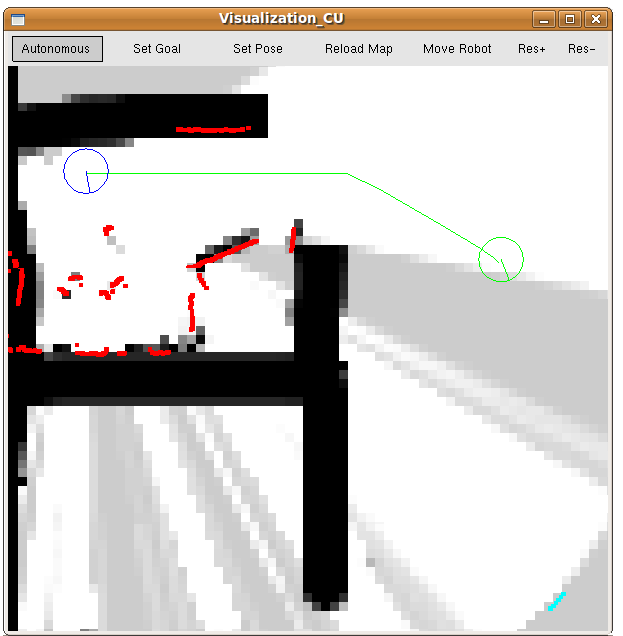
This node provides a graphical interface for interaction with the prairiedog robotic platform. It gives users the ability to visualize the operating environment, set robot and goal positions, switch between autonomous and manual control, and manually control the robot via the keyboard.
GUI

Display
The following is a list of what data is displayed in the GUI:
Map Cost: light to dark represents safe to obstacle (obstacle prob 0 to 1), respectively.
Goal: Green disk with compass needle indicating orientation.
Path: Green lines.
Laser Scan Data: red dots.
Laser Scan Range Exceeded: blue dots at max range
Robot: Disk with compass needle indicating orientation. Color denotes system state as follows:
Blue: normal autonomous mode
Red: bumper hit, backing up
Orange: no path to goal exists
Purple: manual stop
Light-Blue: manual control
Black: uninitialized state
Buttons
The GUI buttons control the system as follows:
Autonomous: The robot moves in autonomous mode, attempting to follow the path. The mouse can be used to re-position and scale the map (left and right buttons, respectively).
Set Goal: Use left mouse button to set the goal position and orientation (click on position and drag in the direction of orientation).
Set Pose: Use left mouse button to set the robot's position and orientation (click on position and drag in the direction of orientation).
reload Map: Explicitly requests the latest map from the map server (may be necessary if automatic map updates have been dropped). Afterward the robot is switched to Autonomous mode.
Move Robot: Allows the user to control the robot with the arrow keys:
Up arrow: increase forward speed (decrease reverse speed)
Down arrow: increase reverse speed (decrease forward speed).
left arrow: increase counter-clockwise rotation (decrease clockwise rotation)
right arrow: increase clockwise rotation (decrease counter-clockwise rotation)
space-bar: stop all movement.
Res+: increase display resolution
Res-: decrease display resolution
Note: the display resolution is only used for visualization purposes and does not affect the mapper or planner. It is useful when visualization_cu is being bogged down by the drawing requirements (this is only an issue in complex environments, when visualization_cu is sharing cpu time with the rest of prairiedog).
Keyboard Shortcuts
Functionality can also be accessed using the keyboard as follows:
arrow keys: translate the map (Autonomous mode), or drive the robot (Move Robot mode)
space-bar: stop all movement (always), resume path following after a stop (Autonomous mode)
-/_: zoom-in
+/=: zoom-out
m/M: switch to Autonomous mode
g/G: switch to Set Goal mode
p/P: switch to Set Pose mode
r/R: reload map (then switch to Autonomous mode)
c/C: switch to Move Robot mode
[/{: increase display resolution
[/{: decrease display resolution
0/): stop all movement (always), resume path following after a stop (Autonomous mode). Same as space-bar
Note: the display resolution is only used for visualization purposes and does not affect the mapper or planner. It is useful when visualization_cu is being bogged down by the drawing requirements (this is only an issue in complex environments, when visualization_cu is sharing cpu time with the rest of prairiedog).
Using an external computer for visualization
When using a separate computer for visualization, the following environment variables must be set appropriately:
On Robot Computer:
export ROS_IP=ip.of.robot.computer
On Visualization Computer:
export ROS_IP=ip.of.visualisation.computer
export ROS_MASTER_URI='http://ip.of.robot.computer:11311/'
API Documentation
visualization_cu
visualization_cu is a graphical interface written in OpenGL/GLUT that displays information about the CU prairiedog platform. It is a light-weight command center, giving users the ability to set robot and goal pose, visualize autonomous behavior by displaying obstacles/robot/goal/paths, and manually control and/or stop the robot.Subscribed Topics
/cu/pose_cu (geometry_msgs/PoseStamped)- The robot's best estimate of where it is, given all pose data, in map coordinates (/map_cu).
- This is a global path between robot and goal in map coordinates (/map_cu).
- pose of the goal in map coordinates (/map_cu)
- A list of laser scan hits, along with the pose of the laser scanner when it captured them. Coordinates are in the map coordinate system (/map_cu in tf)
- Each point in the cloud is a triple (x,y,z). x and y are used to denote which map grid is changed (in map coordinates scaled to resolution) and z is the new cost value of that grid. Note: map updates must be positive and non-zero.
- A flag indicating what state irobot_create_cu is in:
- 0 = initial state (havn't recieved enough info to start moving),
- 1 = planning and moving normally
- 2 = bumper hit, backing up
- 3 = no path to goal exists
- 4 = manual stop
- 5 = manual control
- A flag containing information from the base_planner_cu node:
- 1 = no path to goal exists.
Published Topics
/cu/reset_goal_cu (geometry_msgs/PoseStamped)- A new robot goal in map coordinates (/map_cu).
- A user defined pose, used to manually define the robots starting position with a GUI in map coordinates (/map_cu).
- this is a simple control message for the robot base, x is forward speed and theta is turn in robot coordinates (/robot_cu).
- A flag indicating what the user is doing via the visualization_cu node
- 0 = passive, doing nothing
- 1 = manual stop
- 2 = manual control
Services Called
/cu/get_map_cu (nav_msgs/GetMap)- Provides a map in map coordinates scaled by resolution.
Parameters
prairiedog/using_tf (bool, default: true)- When true, the tf ROS package is used to facilitate coordinate transformations.
- The map coordinate system (/map_cu) is this far off of the world coordinate system (/world_cu) in the x direction. Units are in meters.
- The map coordinate system (/map_cu) is this far off of the world coordinate system (/world_cu) in the y direction. Units are in meters.
- The map coordinate system (/map_cu) is this far off of the world coordinate system (/world_cu) in the radial direction. Units are in radians.
- The radius of the robot in meters.
Required tf Transforms
/map_cu → /world_cu- transformation between map and world coordinates.


